Lote
Livro
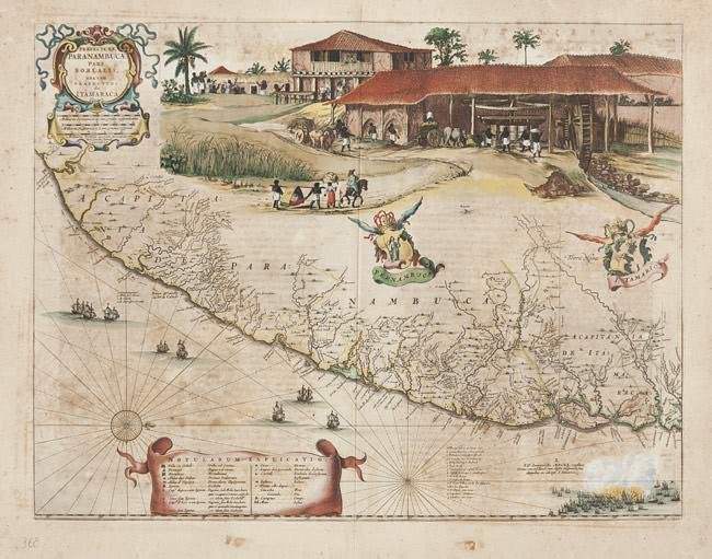
Praefecturae Paranambucae pars borealis una cum prefectura de Itamaraca
BLAEU, J./ MARKGRAF, G./ HERCKMANNS, E. Published in Amsterdam, 1647. Size : 16.5 x 20.9 inches. / 41.8 x 53.0 cm. Colouring: Coloured. Old original coloured.EXTREMELY RARE issue, printed for C.Barlaeus, and before included in the atlas. In very attractive colours. These maps are one of the first maps of Brazil based on Dutch rather than Portuguese interest. The Dutch West India Company, appointed Count Johan Maurits Governor-General of Dutch Brazil in 1636 and was in power until 1644. Upon Maurits return to Europe, he commissioned Kaspar van Baerle to document the flora and fauna, climate, inhabitants, religion, and languages of the coastal provinces of Brazil. The resulting work, "Rerum per octennium in Brasilia" published by Blaeu‘s, is one of the finest works of Brazil ever produced. The maps in this work, with alterations, later appeared in later editions of Joan Blaeu‘s "Atlas Major". This detailed map is highly embellished with cartouches, coats of arms, ships and a sea battle. The large scene on the upper quarter of the map depict the commercially important sugar cane industry. A scarce, important and quite beautiful matching set of two maps. Usado como ilustração no livro do Gaspar Barleus.
Veja também


Novidades do Leilão de Arte!
Seja o primeiro a receber a agenda dos próximos leilões, exposições e novidades de acervo.
Ao assinar, você concorda com a nossa política de privacidade.